Understanding the Critical Role of Title Re-Establishment Surveys for Property Owners in Victoria
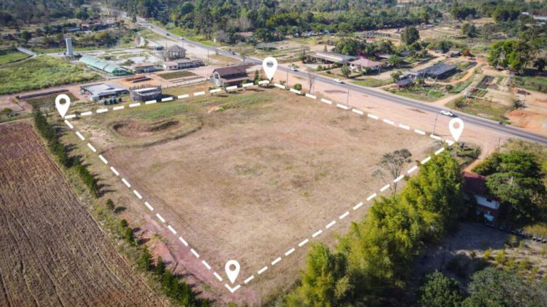
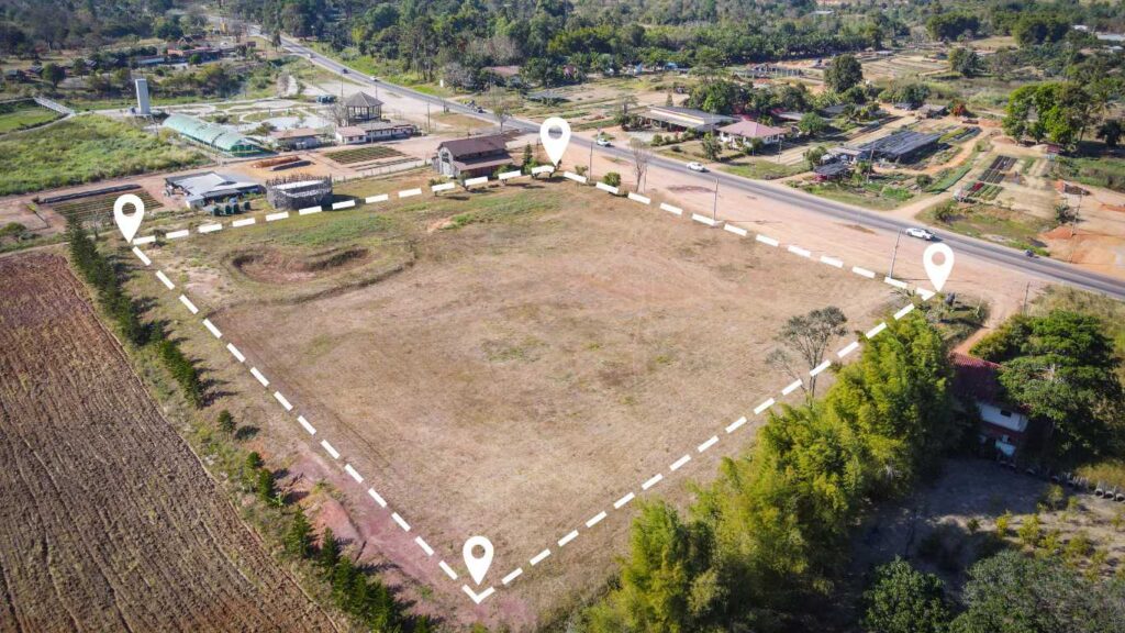
In the diverse and bustling state of Victoria, a Title Re-Establishment Survey, often referred to as a Boundary Survey, serves an essential purpose in accurately defining and marking the legal boundaries of your property as outlined in your Certificate of Title. This comprehensive survey meticulously examines the actual physical characteristics of your land, including fences, buildings, and natural features, and compares them to the registered title dimensions maintained by Land Use Victoria. By engaging in this vital survey, property owners can gain a thorough understanding of their land’s legal boundaries, which is crucial for making informed decisions regarding property development, transactions, and adherence to local regulations.
It is paramount to stress that only a licensed land surveyor is legally authorised to perform a title re-establishment survey. The results of this survey are invaluable for any property owner or developer aiming to accurately ascertain their boundaries before commencing construction, erecting fences, subdividing their land, or addressing boundary disputes. Achieving clarity regarding your property limits can help you avoid significant legal challenges in the future, ensuring peace of mind and safeguarding your investment.
Essential Insights Gained from a Title Re-Establishment Survey
A meticulously conducted title re-establishment survey effectively identifies and documents several critical aspects of your land that are indispensable for property owners:
- The precise title boundaries and corner locations of your property, offering clarity on ownership and averting potential disputes.
- Detection of any existing encroachments from neighbouring properties, including fences or structures that may inadvertently overlap onto your land.
- Comprehensive insights regarding any applicable easements, restrictions, or rights of way that could affect your property’s utilisation.
- Identification of any discrepancies or errors between the land you occupy and the official title boundaries, facilitating timely corrections.
Your qualified surveyor will prepare a detailed survey plan and report that visually represents all boundary markers, relevant measurements, and how they correlate with the official title plan held by Land Use Victoria. This documentation is invaluable for future property transactions, developments, or legal matters, providing you with a robust foundation for making informed decisions.
Optimal Timing for Arranging a Title Re-Establishment Survey
It is wise to schedule a re-establishment survey prior to initiating any projects that depend on precise boundary information. Consider engaging in this survey under the following circumstances:
- Building on or near a boundary, such as constructing a garage, extension, or retaining wall, which could potentially impact your neighbours.
- Constructing a new fence or replacing an existing one, ensuring compliance with legal boundaries and local regulations.
- Subdividing your property or establishing easements, which require a clear understanding of boundary lines to avert legal complications.
- Buying or selling land, especially when boundary locations are ambiguous, to prevent future disputes arising from misunderstandings.
- Resolving boundary disputes or identifying encroachments that may cause conflicts with neighbours, thus fostering amicable relationships.
Even minor inaccuracies in defining boundaries can lead to costly legal disputes or complications regarding regulatory compliance. By obtaining accurate information early in the process, you can conserve significant time, reduce stress, and avoid unexpected expenses down the line, ensuring a smoother property development journey.
The Essential Nature of Title Re-Establishment Surveys for Property Owners
Your title is a vital document that verifies your legal ownership of the property. However, discrepancies may develop over time between the actual physical occupation of your land and the legal boundaries specified in your title. For instance, fences may be rebuilt incorrectly, or structures could slightly encroach on neighbouring properties. Conducting a re-establishment survey is critical to ensure that your property aligns accurately with your legal title, thereby protecting your investment and preventing disputes with neighbours or local councils.
These surveys become especially crucial when applying for subdivisions, boundary adjustments, or planning permits. Without an accurate title re-establishment, you risk encountering delays or outright refusals from local councils and Land Use Victoria, which can hinder your development projects and create complications in your property dealings. Securing this survey not only streamlines your planning process but also fortifies your legal standing.
A Step-by-Step Guide to the Title Re-Establishment Survey Process
- Consultation:
Your surveyor will thoroughly review your Certificate of Title, subdivision plans, and any relevant documents to gather initial information critical for the survey. - Fieldwork:
Employing state-of-the-art GPS technology and total station equipment, your licensed surveyor will visit the site to accurately locate existing boundary markers and physical features, ensuring exceptional precision. - Calculation & Comparison:
The data collected from the field will be meticulously compared with the title dimensions to identify any inconsistencies or potential encroachments that may need addressing. - Reporting:
A comprehensive plan will be created, marking all boundary points, structures, and discrepancies. You will receive this plan in both digital and hard copy formats for your records and future reference. - Lodgement (if necessary):
If discrepancies are discovered, the surveyor can liaise with Land Use Victoria to resolve and update title information, ensuring that your records are accurate and legally compliant.
Why Choose City Land Surveyor Melbourne for Your Surveying Needs?
At City Land Surveyor Melbourne, our team combines licensed expertise, cutting-edge technology, and local knowledge to deliver prompt, precise, and fully compliant re-establishment surveys. Our comprehensive surveys are recognised and accepted by councils, town planners, and building certifiers throughout Victoria, ensuring that you receive a service that meets all regulatory requirements and exceeds your expectations.
 Licensed and experienced Victorian surveyors Utilising advanced GPS and total station technology for precise measurements Transparent, fixed-fee pricing to eliminate unexpected costs Detailed reports tailored for fencing, subdivision, and building applications, ensuring clarity and compliance.
Contact Us Today for Reliable Boundary Surveying Solutions
If you are preparing for a renovation, planning a subdivision, or require expert assistance in resolving a boundary issue, City Land Surveyor Melbourne provides reliable and affordable surveying solutions across Greater Melbourne. Our dedicated team is committed to delivering the highest quality service tailored to meet your specific needs and expectations.
Call (03) 6163 3013 for free advice and a no-obligation quote, or visit citylandsurveyormelbourne.com to learn more about our extensive surveying services.
Title Re-Establishment Survey in Melbourne: Your Gateway to Clarity and Compliance
The Article: Title Re-Establishment Surveys in Victoria Explained first appeared on https://writebuff.com
The Article Re-Establishment Surveys Explained for Victoria Residents Was Found On https://limitsofstrategy.com